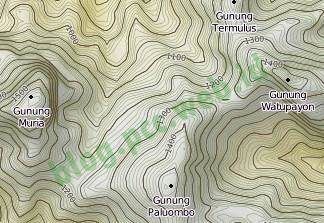
Online Topography Map of Muria Mountains
Learning topography is now easier, with the many technologies that are developing today. If in the past you had to go up and down the mountain to observe conditions in the field, now you can use Google Earth, etc., which has a 3-dimensional display. When I first learned topography, I was still using maps made in the Dutch era. Because I don't know how many times I photocopied it, the contour lines were no longer visible, it was very difficult to imagine the collection of lines into a 3-dimensional form.
What is a Topographic Map? According to wikipedia, the definition of Topographic map is a type of map characterized by large scale and detail, usually using contour lines in modern mapping. A topographic map usually consists of two or more maps that combine to form the whole map. A contour line is a combination of two line segments that are related but do not intersect, these are the elevation points on a topographic map.
Nowadays, many provide online topographic maps, one of which is from opencyclemap.org .Here is a view of the topographic map that I have directed to the mountains of Muria. If you open the site directly we have to search first where the mountains of Muria are located.
Nowadays, many provide online topographic maps, one of which is from opencyclemap.org .Here is a view of the topographic map that I have directed to the mountains of Muria. If you open the site directly we have to search first where the mountains of Muria are located.
or you can go to the site directly for a wider view. www.opencyclemap.org
In the top right corner there is also a tool to change the layer, with 3 options OpenCycleMap, Transport and Landscape. OpenCycleMap is a general view of the topographic map, while Landscape displays a more 3-dimensional map with the curves between valleys and hills more clearly visible. The Transport layer shows only the road map. The top left corner also provides facilities for zooming in and out, as well as shifting the location of the image. The interval distance between contour lines is 10 meters, so each line represents an altitude with an interval of 10 meters. for convenience, an altitude number is provided every 50 meters. In some mountains, one of which is the Mount Merapi hiking trail, there are already hiking trail plots.
Congratulations on learning navigation using online topographic maps, hopefully it will make it easier for us to learn topographic maps.
Congratulations on learning navigation using online topographic maps, hopefully it will make it easier for us to learn topographic maps.
->


